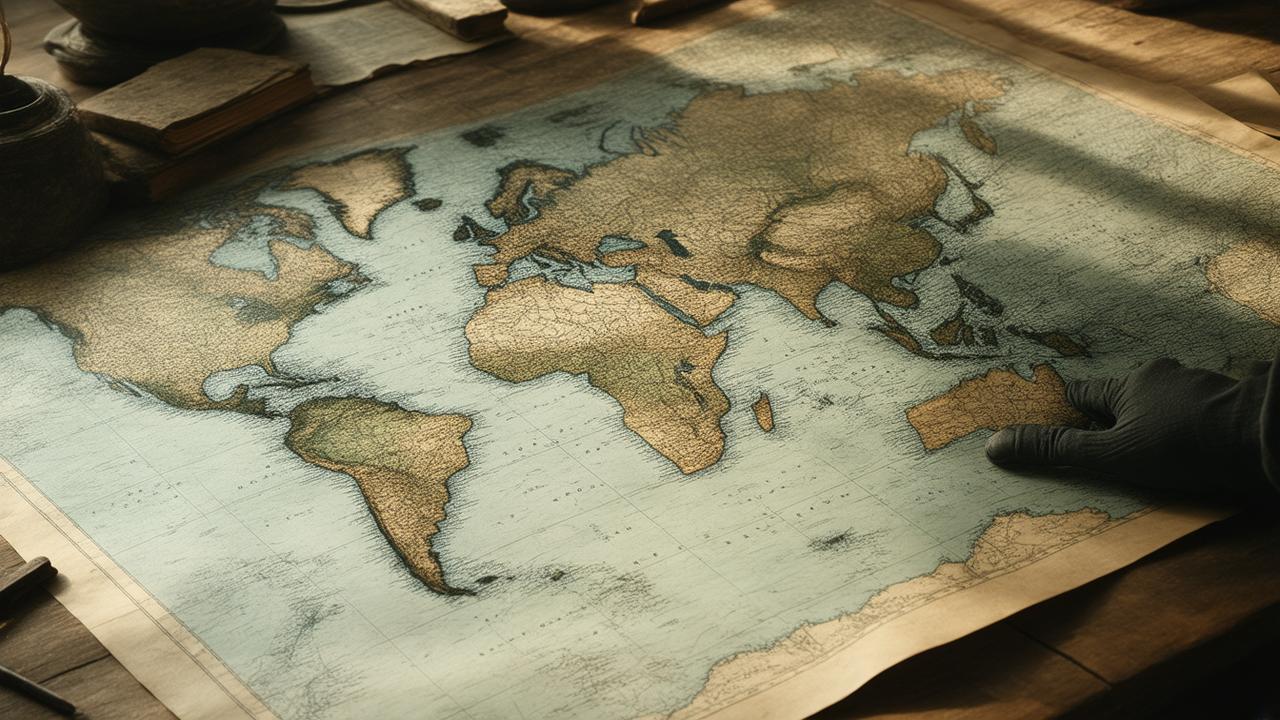
The map is the color of old tea, the edges browned and furred where hands have turned it for more than a century. It lies under glass in a quiet northern archive, humming faintly with that peculiar silence of big rooms and bigger histories. You lean closer. The coastline sketched in iron-gall ink looks almost familiar—until it doesn’t. A bay where no bay exists on modern charts. A tiny cross denoting a “landing.” A smudge of letters: a name you’ve never heard, written where—according to the official histories—no one from across the sea was supposed to have landed that early. Suddenly, the north feels far less settled, far less known.
The Coastlines That Don’t Sit Still
Coastlines pretend to be solid things on paper. A jealously inked line between land and sea. On the page they look permanent, authoritative, almost arrogant. But if you’ve ever stood on a northern shore with the autumn wind in your face, you know better.
The shore is never the same twice. Tides heave up and down, ice piles in ridges and then melts away. Storms tear out whole teeth of headland in one wild night. Permafrost slumps and slides. Beaches migrate grain by grain on the backs of longshore currents. Rivers braid and unbraid themselves, rethinking their mouths. The north is a slow-motion earthquake of water, ice, and time.
For centuries, though, official histories have treated northern coastlines as fixed backdrops in a familiar story: early European contact limited to certain harbors, certain “known” routes, certain safe narratives. Everything else? Empty. Untouched. Waiting politely offstage.
Old maps and coastal records are starting to tear that backdrop wide open.
When Old Paper Outruns New Certainty
In archives from Copenhagen to Ottawa to small regional museums with leaky roofs, scholars are pulling rolled charts from tubes and unfolding atlases that haven’t seen daylight in decades. On these aging sheets, the north looks uncanny—familiar, yet off-kilter. Bays where satellite images show straight shore. Island clusters no longer there. Harbors named after people who, officially, “were never there.”
Many of these maps were drawn by sailors, traders, whalers, and explorers who hugged the coastlines, sometimes forced ashore by ice or storms. Their notes, jotted in margins or tucked into logbooks, record places where they anchored, traded, or simply waited out bad weather. For a long time, historians treated these as colorful footnotes, unreliable whispers from the past.
But digital tools, GIS mapping, and collaborations with local and Indigenous knowledge holders are changing that. When you line these old maps up with modern satellite imagery and—crucially—with oral histories that have never fit the official timelines, a different picture appears. The coast shifts under your feet. So does the story.
The Coastal Records That Refused to Stay Quiet
Some of the richest evidence doesn’t come from grand “exploration” maps at all, but from the workaday records of coastal life: whaling logs, mission journals, fur-trade inventories, even tide tables scribbled in the margins of almanacs. These documents smell of whale oil, damp wool, tobacco, and candle soot. They were never meant to rewrite history. And yet, here we are.
Imagine a whaling ship log from the late 1600s, its pages stained by salt and grease. Between descriptions of ice conditions and wind shifts, a short line appears: “Traded fresh fish and skins with people on shore; they came in three kayaks.” According to the official narrative, that particular stretch of coast didn’t see regular European presence for another hundred years. But the ship’s captain, intimately familiar with risk and reward, had no reason to invent such a meeting. To him, it was just Thursday.
Now multiply that small, throwaway detail by dozens of similar entries scattered through time. A mission record noting a gift of woven grass mats. A merchant’s ledger listing “northern cod, traded from locals” well before formal trading posts stand on any state record. A coastal survey marking a “native village” on a beach modern charts show as barren sand—except that elders nearby still tell stories of that old settlement, its houses long melted back into the earth.
What the Old Maps Are Actually Showing Us
The new work isn’t about proving that one particular ship, famously or infamously, reached one particular bay. It’s about patterns. The kind of patterns that only emerge when you stop listening only to national archives and start listening to everything—maps, logs, place names, and people.
Scholars, cartographers, and community researchers are combining multiple layers of evidence:
| Evidence Type | What It Reveals | Why It Matters |
|---|---|---|
| Early nautical charts | Unusual harbor names, penciled routes, and notes of “landings” | Suggests previously unrecognized visits and anchorages |
| Ship logs & journals | Daily records of weather, trade, encounters with people on shore | Provides specific times and places of early contact events |
| Indigenous oral histories | Stories of “strange ships,” new materials, or distant visitors | Offers long-term memory that either aligns with or challenges paper records |
| Coastal geomorphology | Evidence of old shorelines, eroded settlements, ancient beaches | Explains why land on old maps doesn’t match modern coastlines |
| Place names | Names referring to “ship,” “metal,” “trade,” or foreign peoples | Hints at remembered encounters hidden in everyday language |
When these layers stack up—when a 17th-century harbor name appears exactly where elders recall a story of early visitors, and where coastal sediment cores show an old sheltered bay silted in long ago—you no longer have coincidence. You have contact.
Coastlines That Moved, Stories That Stayed
The north is not just cold; it’s restless. In many Arctic and sub-Arctic regions, the land itself is rising, rebounding from the weight of vanished ice sheets. What was once shoreline becomes scrubby interior. Old harbor sites end up stranded above the tide line, their wharves now overlooking willow and rock. On other coasts, fierce storms and thawing permafrost accelerate erosion, sending old village sites sliding into the sea.
This matters because early contact so often clung to the edges—those fragile boundary zones where deep-drafted ships could lie just offshore while small boats darted in and out. Many of the places where first cautious exchanges took place no longer look like the maps that recorded them. The bay has narrowed. The protective sandbar is gone. A half-sunken spit of rock now wears only cormorants and a scattering of driftwood.
For years, historians shrugged off certain map features as “errors.” That little island that doesn’t exist. That curving bay where only a cramped inlet survives. Now, geologists and coastal scientists are quietly stepping into the conversation and saying: Maybe that island did exist—in 1650. Maybe that bay really did open wide before a couple centuries of sediment closed its throat.
In this light, an old map stops looking like a flawed attempt to depict our world, and starts looking like a precise portrait of a coastline that simply doesn’t exist anymore. The mismatch between past and present geography becomes a clue, not a condemnation.
The Contact Stories Hidden Between the Lines
Once you treat early charts as time-stamped images instead of faulty drafts, a new story pushes through the paper. Take the cryptic notations—small crosses, circles, or brief words cramped in the margins. A captain marking “good water,” “anchorage with natives,” or simply “met people here.” These scribbles were practical notes for mariners. Today, they are coordinates in a narrative that never made it into school textbooks.
Local communities sometimes recognize these places instantly. A point labeled with a strange European name might sit right beside an Indigenous name that translates to “place where the first big boat came.” That alignment sends a quiet electric thrill through research teams gathered around laptops and photocopies. Verification doesn’t always look like a smoking gun; sometimes it looks like two different languages describing the same event from opposite shores.
And then there are the silences. Some maps are heavily annotated along parts of the coast and eerily blank along others. Blankness has too often been read as absence: no people, no visits, nothing to see. But as Indigenous scholars have long pointed out, “blank” usually just means “not recorded by them.” The new mapping work reads absence differently, asking why some encounters were deemed too ordinary, too transactional, or too politically awkward to ink on state-sanctioned maps—even as they lived on in local stories and quiet logbooks.
Rewriting “First Contact” in the North
Most of us grew up with a simple sequence: at some official year, a named expedition “discovered” a bay, a river mouth, a passage. The story leaned heavily on singular moments and famous men, usually standing stiffly on shore in heavy coats, planting flags into the sand. What the old maps and coastal records are revealing is something messier and much more human.
➡️ Australia’s space industry is quietly expanding beyond satellites into deep tech exports
➡️ Emergency wards are reporting a sharper spike in dehydration cases during prolonged heatwaves
➡️ Bushfire smoke is turning air quality monitors into everyday household essentials
➡️ How Australian parents are navigating a new era of digital childhood boundaries
➡️ East coast councils are rewriting heat plans as pavement temperatures climb year after year
➡️ Ancient rock shelters in the Kimberley are forcing new debates about heritage enforcement
➡️ Seawall upgrades are accelerating as coastal communities brace for stronger storm surges
Early contact in the north was not a single dramatic landing but a long, uneven drizzle of visits, sightings, tentative trades, and wary withdrawals. A whaling crew sheltering in a small cove after a storm, sharing tobacco and knives for fresh seal meat. A coastal community spotting sails on the horizon, then watching for years as ships came closer, then went away again, like a new kind of migrating animal. Contact might arrive first as sound—the crack of distant guns, the thud of anchors—long before a stranger’s boot touched gravel.
These prolonged, intermittent encounters left their imprint not only on maps but on material culture. Iron nails turned into tools. Foreign textiles cut and resewn into local garments. Storylines braided together: tales of dangerous storms that happened to coincide with the arrival of a strange-rigged ship; stories of new diseases following the appearance of “wooden islands” offshore.
The new cartographic work nudges our understanding away from heroic discovery and toward entanglement. Instead of one side arriving at a blank northern stage, we begin to see multiple actors, each with their own mental maps, meeting along edges that were already rich with meaning.
Who Gets to Draw the Coastline?
Underneath the technical work of digitizing maps and reconstructing old shorelines lies a quieter question: who gets to decide what counts as real? For generations, state archives—and the maps they cherished—claimed that authority. If it wasn’t inked in a European hand, it barely existed in the historical imagination.
Now, research teams are bringing copies of old charts back to communities whose ancestors watched those first sails approach. The conversations can be unexpectedly intimate. An elder laughs softly at a misspelled place name, then points to a bay on the map and says, “They slept here. My grandfather’s grandfather told me of it.”
In those rooms, the paper artifacts and the living memory lean toward each other like two halves of a broken bone setting at last. Misalignments are as instructive as matches. When an old chart insists on a coastal “village” where local memory says there was only ever a seasonal camp, it raises questions: Did the mapmaker misinterpret? Exaggerate? Or did the camp once grow larger under the gravitational pull of early trade?
Living with a Coast That Keeps Changing
Maybe the most unsettling lesson in all this is that the maps will never be finished. The northern coasts are still moving—eroding, thawing, rising. Some of the very sites now being identified as early contact locations are slipping into the sea as warming accelerates. Graves appear from crumbling bluffs; timbers from old houses tumble onto storm beaches. The line between past and present is growing as blurred as the line between land and water on those old tea-colored charts.
In a way, it feels fitting. The story of early contact in the north is not a neat arc; it’s a coastline itself—jagged, scalloped, constantly revised. Old maps laid over modern imagery don’t close the book, they pry it open further. They invite us to listen more closely to people whose histories were long treated as “supplementary.” They remind us that every clean line on a map is an argument as much as a description.
Somewhere right now, in a windowless archive, another rolled chart is waiting to be uncurled for the first time in decades. Somewhere, a community researcher is sitting at a kitchen table, tracing a finger along a faded coastline, saying, “This part here—this is wrong. Let me tell you how it really was.” Between them, the north’s story is shifting again, tidal and alive, refusing to stay nailed to the page.
Frequently Asked Questions
Why are old maps changing our understanding of early contact in the north?
Old maps preserve details about landings, harbors, and trade encounters that were never folded into official national histories. When these details are compared with oral histories, archaeological findings, and modern coastal science, they reveal earlier and more widespread contact than previously recognized.
How can we trust maps that don’t match modern coastlines?
Coastlines in many northern regions have changed significantly due to land uplift, erosion, sea-level changes, and shifting sediments. What once looked like an error may now be understood as an accurate depiction of a shoreline that has since transformed.
What role do Indigenous oral histories play in this new picture?
Indigenous oral histories offer long-term memory of events like the arrival of strange ships, new materials, or unfamiliar diseases. When these stories align with old charts and ship logs, they strengthen the case for revising timelines and routes of early contact.
Are these discoveries just about European explorers?
No. While European and other foreign maps and logs are important, the emerging story centers on relationships and interactions, not solo exploits. It highlights how coastal communities responded to, negotiated with, and sometimes resisted these early visitors.
What does this mean for how we teach northern history?
It suggests moving away from simple “first contact” dates and heroic discovery narratives. Instead, teaching can focus on ongoing, reciprocal encounters, the complexity of local agency, and the way knowledge—both mapped and remembered—shapes what we believe about the past.