The first thing you notice is the silence. Not the absence of sound, exactly, but a deep, padded quiet that hangs over the flat horizon, where sky and water blur into a single sheet of pearl-grey. You stand on a strip of land the maps say is real, but your bones insist is borrowed. In every direction, the world feels newly assembled—young dikes, newborn dunes, water that has been trained like a dog to heel at a precise line of stone. Somewhere beneath your boots, the sea remembers that this used to be its territory. Somewhere beneath the surface, rivers you cannot see are running in directions they were never meant to go.
When a Country Decides to Redraw Itself
In the Netherlands, the line between land and sea has always been more of a suggestion than a rule. But in the last decade or so, that suggestion has been aggressively edited. While the world watched other climate headlines—burning forests, melting ice, rising seas—this small, stubborn country on the North Sea quietly did something audacious: it began to divert entire rivers, reshape its coastline, and coax vast stretches of “new” land from saltwater and silt.
This wasn’t done with a single heroic project but through a slow, deliberate choreography of engineering and ecology. A canal turned here, an estuary widened there, a river mouth relocated miles from where it once spilled into the sea. All of it adding up to what feels, standing amid the wind and the reeds, like a quiet revolution in geography.
Officially, it sits under calm bureaucratic names—coastal realignment, river re-routing, sand nourishment, adaptive delta management. But walk out onto a polder that didn’t exist when you were a child, or stand on the crest of a man‑made dune watching the waves break exactly where planners predicted they would, and the language feels too small. What the Netherlands has done is nothing less than rewrite the story of its own coastline—chapter by chapter, tide by tide.
The Secret Life of Rivers That Changed Direction
To understand how a country diverts rivers without the rest of the world quite noticing, you have to step away from the postcard views of windmills and tulips and spend time where the water decisions are made. Here, the rivers are not just scenic backdrops; they are living, shifting infrastructures that deliver silt, drinkable water, and danger in equal measure.
For years, Dutch planners understood rivers as threats that needed to be pinned down by levees, dams, and concrete. But as sea levels crept higher and extreme rainfall began pushing rivers to their limits, a new question emerged: What if control wasn’t about squeezing the water into narrower channels, but about giving it more space—just in the right places?
Across the lowlands, that question turned into an experiment carried out in real time. Some river branches were nudged into new courses. Floodplains once hemmed in by dikes were opened up to temporary flooding. Old channels were abandoned so that new ones—wider, slower, more forgiving—could snake their way toward the sea. In some places, the sea itself was invited a little closer inland, so that sand and sediment could be harvested by tides and currents, then quietly layered onto the coast.
If you were a fish, you would have felt it as an altered journey—new bends, gentler gradients, a different flavor of water at your gills as fresh and salt now met in re‑plumbed estuaries. If you were a sand grain, you might have taken a different ride to the shore, settling not in a random shoal but on a carefully designed bar that would, in time, become part of a reinforced beach. If you were a person, you might not have noticed anything at all, unless one day you realized the map of your childhood river no longer matched the real one outside your window.
Reclaiming Land Without Waging War on the Sea
The Netherlands has spent centuries pulling land out of the sea by sheer force: massive dikes, drained lagoons, dizzying pumping systems that never rest. Those earlier eras had a clear villain—the water—and a clear strategy: build higher walls and keep the enemy out. But this recent, quieter reshaping of the coast has had a different mood.
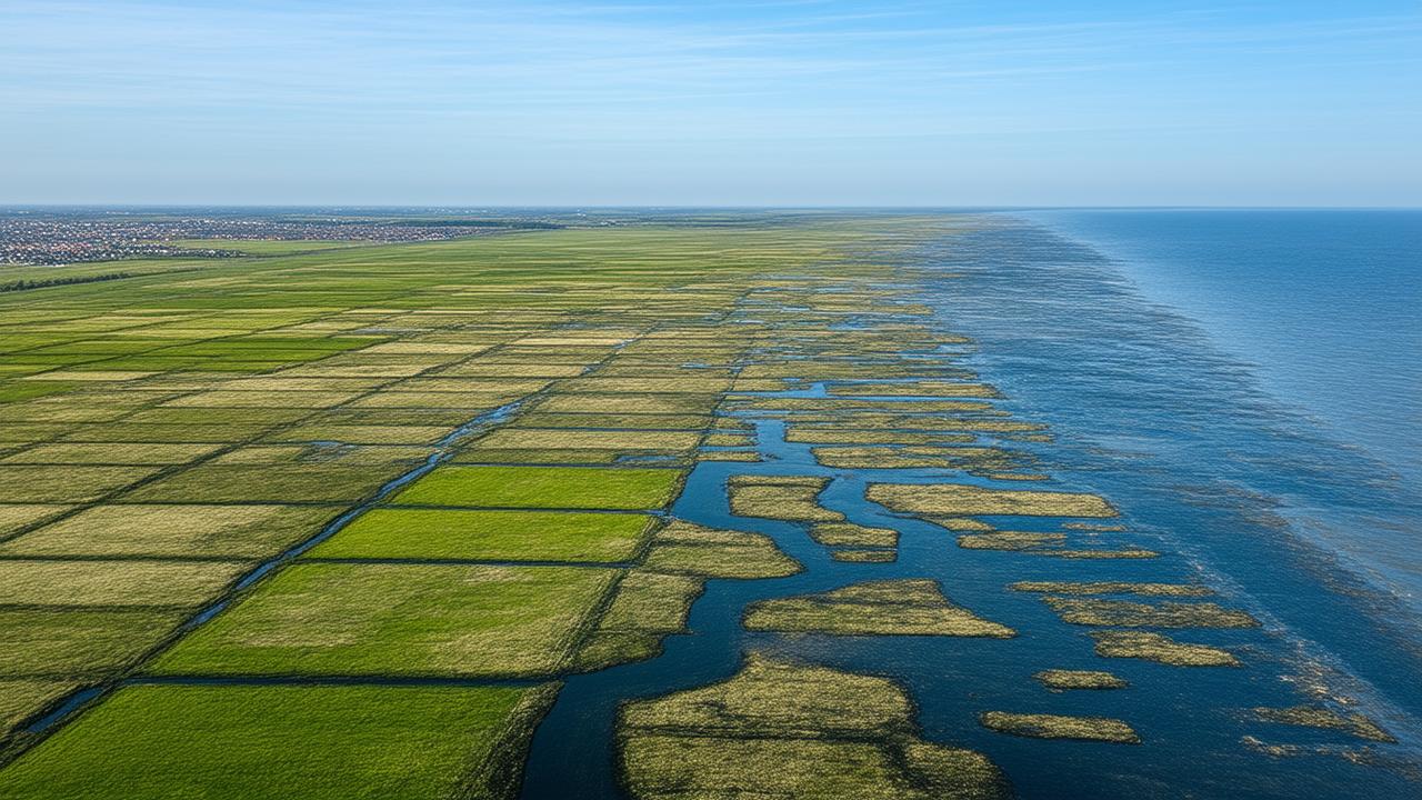
Standing at the edge of a new coastal polder on a damp winter morning, you can see that mood written into the landscape. The dike behind you is still there, but it’s farther back, thicker, less like a wall and more like a long, low hill. In front of it stretches a broad apron of marsh, reed bed, and sand sheet. From a distance, it looks chaotic—a tangle of creek channels zigzagging through mud, flocks of waders probing for food, the constant hiss of wind over sedges. Up close, you start to see the plan: this is not leftover land; it is a deliberate buffer zone, a place built to absorb the violence of storms so the dike doesn’t have to.
Here, river water empties into a shallow, semi‑enclosed lagoon instead of rushing straight to sea. Sediment fans out and settles. Slowly, tidal flats rise into salt marshes, stitched together by the roots of plants that don’t mind a bit of brine. The more the marsh grows, the more it softens the waves. Every storm that crashes in leaves a little more sand, a little more silt, thickening the natural shield.
In this version of land reclamation, the country isn’t so much conquering the sea as bargaining with it—offering space and flexibility in exchange for safety and, yes, more land.
The Subtle Art of Moving Coastlines
Perhaps the most startling thing is how normal it all looks. For travelers arriving by train or car, the reshaped coastline feels unremarkable: another flat horizon, another tangle of cycling paths, another flock of sheep grazing on a green slope that doubles as a flood defense. Yet beneath that surface ordinariness lies a decade of near‑constant adjustment.
Instead of pouring more concrete, Dutch engineers have leaned into what they’ve come to call “working with nature.” Picture this: an enormous volume of sand, dredged from offshore, is deposited in a single, bulbous “sand motor” or hook‑shaped peninsula. Over years, waves and currents slowly carve that sand apart and smear it along tens of kilometers of coastline, thickening beaches and shoals almost by accident—or so it appears. But of course, the shape, location, and volume of that initial sand mass are anything but accidental.
The coastline, nudged by physics and human intent, begins to inch outward. A dune that was once the last ridge before open water becomes second to last. Behind it, low-lying ground that once would have flooded in every major storm now sits just a bit safer, its odds slightly improved by a few extra meters of beach and a better-placed break in the waves.
It’s easy to miss the scale of this change when you’re standing within it. So imagine looking down from above, time sped up. You would see river mouths shift like the ends of moving brushstrokes. You’d see new spits of land appear and lengthen; the bright ribbon of surf bending and re‑bending along the shore. What looks still and solid on a summer afternoon is, over ten years, as restless and alive as the water that shapes it.
The Quiet Numbers Behind a Moving Shore
A transformation this large can feel abstract until you trace it in simple terms. These are not the final word—coastlines are always changing—but they sketch the outline of what has already happened.
| Aspect | Approximate Change (Last Decade) |
|---|---|
| Newly reclaimed or elevated coastal land | Tens of square kilometers of polders, dunes, and marsh buffers added or raised |
| Rivers and channels subtly re‑routed | Multiple river branches, estuaries, and canals adjusted to spread floodwaters and sediment |
| Sand moved along the coast | Millions of cubic meters nourished onto beaches and offshore sand motors |
| New or reinforced natural buffers | Extensive stretches of restored dunes, salt marsh, and tidal flats protecting inland dikes |
| Flood risk in key low‑lying zones | Reduced through a combined strategy of river diversion, room for water, and coastal widening |
These numbers are not shouted from rooftops. They live in planning documents, in the memory of dredger captains, in the experiences of farmers whose fields now sit behind newly sculpted dunes. The coastline has been moved—not in a single dramatic leap, but through the steady, cumulative logic of a country that long ago decided it would not retreat inland if it could instead persuade the land itself to grow.
Listening to the Landscape’s New Language
Walk these reimagined edges on a stormy day and the changes feel less like an engineering project and more like a new kind of conversation. The wind shoves at your chest; the rain comes sideways in bright, sharp sheets. Out at sea, waves rear up and break in a chain of white collapses, spending themselves first on sandbars that did not used to exist, then on a wide, forgiving shelf of shallow water, and then—only then—on the higher beaches.
Behind the dunes, where the land has risen just enough, a farmhouse light flicks on, steady and unworried. Cows keep chewing. A cyclist leans harder into the wind but doesn’t alter her route. The drama at the shoreline has been deliberately pushed outward, away from living rooms and schools and train stations, into a zone where the country can afford to let the sea be wild.
➡️ Marine biologists warn of a troubling shift in orca interactions with vessels, as new research suggests learned aggression and humans refuse to change course
➡️ Psychology explains why overthinking at night is closely linked to the brain processing unresolved emotions
➡️ The forgotten kitchen liquid that leaves grimy cabinets smooth, clean, and shiny again with surprisingly little effort
➡️ “I’m a hairdresser, and this is the short haircut I recommend most to clients with fine hair after 50”
➡️ Drivers receive welcome news as new licence rules are set to benefit older motorists across the country
➡️ New spacecraft images expose interstellar comet 3I ATLAS with a level of detail scientists never expected
➡️ A retiree wins €71.5 million in the lottery, but loses all his winnings a week later because of an app
If you pay attention, you can hear the new language of this landscape in smaller details, too. A line of willow trees planted in what looks like an odd, sideways zigzag reveals itself, in flood season, as a natural speed‑bump for water rushing through a river’s expanded floodplain. A patch of “messy” wetland, humming with insects in summer, turns out to be a precisely calculated sponge, ready to hold excess water when river levels spike.
This is perhaps the most radical aspect of the Netherlands’ quiet coastal reimagining: the decision to let certain places be temporarily wet or wild, so that most places can remain reliably dry and ordinary. The rivers, once straight‑jacketed, are being allowed to wriggle a little again—but always within an invisible architecture of safety.
What It Means for a Country to Choose Persistence
In an age of rising seas, many coastal nations face a bleak calculus: retreat, armor up, or risk catastrophe. The Netherlands has chosen something more nuanced—an ongoing, negotiated persistence. It is not pretending the sea isn’t climbing. It is not betting everything on walls that must be raised every few decades. Instead, it has entered into a kind of long‑term relationship with water in motion.
Diverting rivers over a decade is not glamorous work. It involves years of study, political argument, consultations with farmers and fishers, recalibrations when a pilot project behaves unexpectedly. It is as much about patience as it is about pumps and dredgers. Yet the result, seen from a quiet dune on a grey afternoon, feels almost effortless—as if this new coastline had grown here on its own, rather than been coaxed into being by design.
That apparent effortlessness is deceptive, of course. It hides not just engineering genius, but also a cultural choice: to accept that the map of the nation will never be finished. That rivers may need to move again. That a dike might one day become an inland hill as new land accretes in front of it. That the edge of the country is less a line than a zone—flexible, layered, alive.
For now, the Netherlands stands as a kind of living experiment in how a low‑lying nation might face the future without surrendering to it. Its rivers, bent into new paths, are carrying more than water and silt; they are carrying a story of quiet defiance and careful adaptation. And somewhere beneath that soft, padded silence on the coast, the sea knows it has met not an enemy, but a very determined negotiator.
Frequently Asked Questions
Has the Netherlands really diverted entire rivers?
Yes. Over the past decade and more, the Netherlands has subtly redirected and reshaped several river branches, floodplains, and channels. These changes are not usually dramatic straight‑line relocations but careful adjustments that widen paths, create new side channels, or shift where and how rivers meet the sea.
Why is the Netherlands reshaping its coastline?
The main reasons are flood protection, sea‑level rise, and the need for more resilient land. By widening beaches, restoring dunes and marshes, and redirecting rivers to spread water and sediment more intelligently, the country reduces flood risks while also creating new or safer areas for people, farming, and nature.
Is land reclamation still happening in the traditional way?
Classic polder creation—building a dike, draining water, and pumping continuously—still exists, but it is no longer the only or even the dominant strategy. Modern projects often combine limited hard infrastructure with large areas of natural buffer zones, such as wetlands and dunes, that work with tides and storms instead of simply resisting them.
Does this coastal reshaping harm wildlife?
Any large landscape change affects ecosystems, but many recent Dutch projects have been designed to benefit wildlife as well as people. Restored estuaries, tidal flats, and marshes often provide richer habitats for birds, fish, and invertebrates than the narrow, armored coastlines or heavily constrained riverbanks they replace.
Can other countries copy what the Netherlands is doing?
The basic ideas—giving rivers more room, using sand and sediment to build wider coasts, and creating natural buffers—can be adapted elsewhere. However, each coastline and river system is unique. What the Netherlands offers is not a simple template, but a demonstration that it is possible to live with water dynamically, reshaping the edge of a nation over time instead of treating it as a fixed line on a map.